-
-
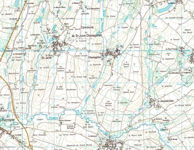
St. Juire A
IGN Map, unalteredWherever I exhibit, I like to do at least one site-specific piece. The first time I used flooding as an intervention was for a show in the small village of St. Juire Champigllon, where my friend Bruno Chambelland was mayor. It is in a very low, hot area of the Vendée region, which becomes very still in summer. Bruno lives in a beautiful castle, yet all his friends complained that there was no body of water in the area...no pond, no lake, nowhere to swim during the heat. What better way to provide water than to have global warming make the nearby Atlantic rise and let the sea push inward? Once it rose right to the castle’s terrace, everyone could jump right in. I bought two maps: this one, framed but untouched; and the other, to work on... (continued with next image, “St. Jurie B”)
-
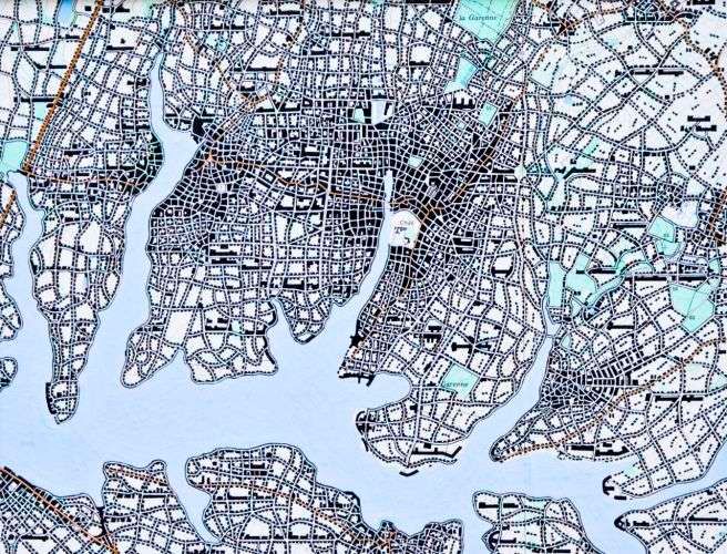
St. Juire B
1997 (Ink & Gouache over IGN Map/19 X 24.5cm) #97007(continued from previous image) I went around the elevation lines of the map at 34 meters, which is the height of the castle terrace. As the sea rose to meet my mark, the towns and cities along the nearby coast , like La Rochelle with its 120,000+ people, had to move upland to survive. And with the creation of so much shoreline along this new inlet, it seemed natural for St. Juire to develop into a proper city. Now, instead of being mayor of a village of 1,000, Bruno became mayor of a city of 400,000 with -- thanks to my help -- his castle smack in the center.My "Graphic Obliteration Mandate" is a constraint I give myself whenever I work with an existing map. This "law" says that I must work over all the graphic type so it is no longer visible to the viewer. (It's why you may notice some very looong buildings). In this peice, I did make an exception for the green spaces, such as parks.
-
-
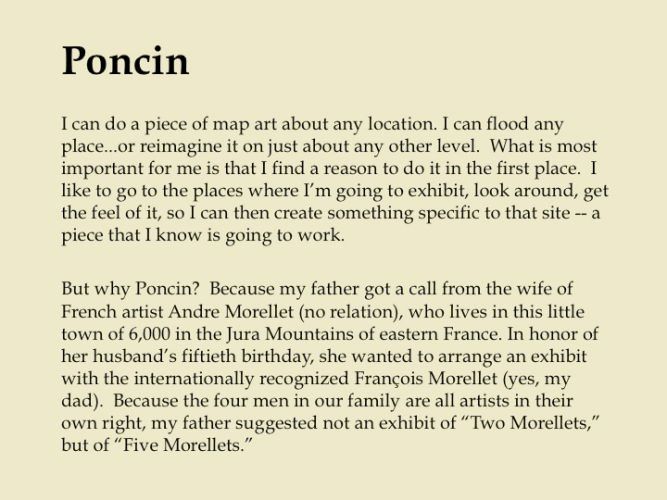
![2000 [Black ink on artist's printed map [river & elevation)]/18 X18cm) #00002The name “Jura” comes from Jurassic, and The Jura Mountains are from that period. They are much more like the Appalachian Mountains in America than the nearby Alps -- parallel ridges where the only passages are through sharp deep gaps. Poncin is just upstream of one of these gaps. “A-ha,” I thought. “The perfect place to put a dam.” In addition, I also know, from personal experience, that little towns are boring. My premise, then, was to to develop their town of 6,000 people to one of 100,000. I did this in four different ways working with the Jura River in its own terrain. First, as here, without a dam. This shows how the city would expand organically, in line with its current topography. The second piece shows how Poncin would grow with a little dam flooding the valley to a certain elevation. Next, with the shoreline created by a big dam. And lastly, how it would have to grow around the flooding fr Poncin - No Dam](https://static.livebooks.com/b8c3b0a07fce495a8fa859391f26eb7a/i/cd5556114ff44156b6f924ef698369ff/2/GCuCv726vxAVM9sgguVj4g/5_0_201_1Poncin_no_dam_00002.jpg)
Poncin - No Dam
2000 [Black ink on artist's printed map [river & elevation)]/18 X18cm) #00002The name “Jura” comes from Jurassic, and The Jura Mountains are from that period. They are much more like the Appalachian Mountains in America than the nearby Alps -- parallel ridges where the only passages are through sharp deep gaps. Poncin is just upstream of one of these gaps. “A-ha,” I thought. “The perfect place to put a dam.” In addition, I also know, from personal experience, that little towns are boring. My premise, then, was to to develop their town of 6,000 people to one of 100,000. I did this in four different ways working with the Jura River in its own terrain. First, as here, without a dam. This shows how the city would expand organically, in line with its current topography. The second piece shows how Poncin would grow with a little dam flooding the valley to a certain elevation. Next, with the shoreline created by a big dam. And lastly, how it would have to grow around the flooding fr
-
![2000 (Black ink on artist's printed map [river & elevation]/18 X 18cm) #00003(continued from previous slide) A map stops, you know, where the water stops. When you build a dam, the map changes as the reservoir you are creating reaches its desired elevation. With a little dam, Poncin’s population of 100,000 -- that is, my Poncin's population of 100,000 -- would have to fit into a slightly different configuration. The density would still follow the line of the river and its small tributary, which would grow a bit wider. (text continues with next image) Poncin - Little Dam](https://static.livebooks.com/b8c3b0a07fce495a8fa859391f26eb7a/i/d75a432efe7a400f9f6684eb78c38a77/2/GCuCv726vxAVM9sgguVj4g/6_0_42_1poncin2.jpg)
Poncin - Little Dam
2000 (Black ink on artist's printed map [river & elevation]/18 X 18cm) #00003(continued from previous slide) A map stops, you know, where the water stops. When you build a dam, the map changes as the reservoir you are creating reaches its desired elevation. With a little dam, Poncin’s population of 100,000 -- that is, my Poncin's population of 100,000 -- would have to fit into a slightly different configuration. The density would still follow the line of the river and its small tributary, which would grow a bit wider. (text continues with next image)
-
![2000 (Black ink on artist's printed map [river & elevation]/18 X 18cm) #00004(continued from previous slide) A big dam, as shown here, would cause Poncin’s configuration to change more dramatically. The valley becomes much more apparent when you see how it would look when filled with water. Its citizens would be drawn to live and build on the most desirable land -- that of its long shoreline. (text continues with next image) Poncin - Big Dam](https://static.livebooks.com/b8c3b0a07fce495a8fa859391f26eb7a/i/e1b6a8189a60494687b6201f5992d074/2/GCuCv726vxAVM9sgguVj4g/7_0_202_1Poncin_big_dam_00004.jpg)
Poncin - Big Dam
2000 (Black ink on artist's printed map [river & elevation]/18 X 18cm) #00004(continued from previous slide) A big dam, as shown here, would cause Poncin’s configuration to change more dramatically. The valley becomes much more apparent when you see how it would look when filled with water. Its citizens would be drawn to live and build on the most desirable land -- that of its long shoreline. (text continues with next image)
-
![2000 (Black ink on artist's printed map [river & elevation]/18 X 18cm) #00005(continued from previous slide) Now you can see how the reservoir of a really big dam would make the urban growth cradle right into the tighter, more concave shoreline as the water forced it to a higher elevation. Poncin would have the same density of 100,000, but it would have to develop quite differently.Technically, I started the series using the IGN map (the French Government’s topographical map). I traced the curves of the elevation lines on vellum and made four copies. Then I worked with graphic designer Douglas Riccardi in inserting each of the different-sized dams into one of the copies. With each bigger dam, we filled-in with blue up to the elevation where the water would find its level. Poncin - Very Big Dam](https://static.livebooks.com/b8c3b0a07fce495a8fa859391f26eb7a/i/c3c2dece9f894deeb6092f2bbbc2e52b/2/GCuCv726vxAVM9sgguVj4g/8_0_46_1poncin4.jpg)
Poncin - Very Big Dam
2000 (Black ink on artist's printed map [river & elevation]/18 X 18cm) #00005(continued from previous slide) Now you can see how the reservoir of a really big dam would make the urban growth cradle right into the tighter, more concave shoreline as the water forced it to a higher elevation. Poncin would have the same density of 100,000, but it would have to develop quite differently.Technically, I started the series using the IGN map (the French Government’s topographical map). I traced the curves of the elevation lines on vellum and made four copies. Then I worked with graphic designer Douglas Riccardi in inserting each of the different-sized dams into one of the copies. With each bigger dam, we filled-in with blue up to the elevation where the water would find its level.
-
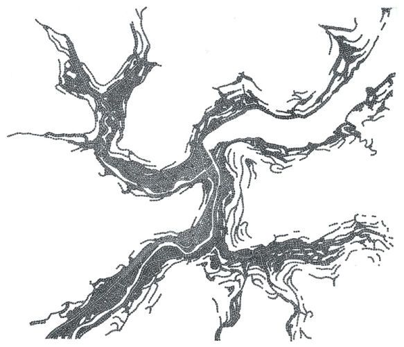
Phoenicia (Gambling in The Catskills)
2004 (Ink on vellum/27.5 X 34.5cm) #04003My first hiking in the Catskill Mountains of New York was around the hamlet of Phoenicia, nestled where several valleys converge. For years, lawmakers in our state capital of Albany have been stalemated around the wisdom of bringing the economic miracle of gambling to the poor citizens of this depressed region.Dramatic Interference was called for. With a wave of my magic legislative wand, it became a fait accompli. First, I built a large dam downriver to get water and electricity -- but most importantly to create a lake where huge new casinos could line-up at the water's edge for picture-perfect postcards. Instantly, a meandering city of a quarter-million people grew, taking over one valley after another, looking like a convoluted Chinese dragon.“Phoenicia” is drawn with black ink on vellum laid over US Geological Maps. This technique insures that I will be faithful to the geography. That map is then removed and replaced with a white back
-
-
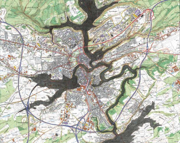
Luxembourg "Blue Print"
2007 (Pencil on IGN map) #07000This defines the contour lines at an elevation of 274 meters, so it shows the points the water would reach the city whether filled "fast" (via humans) or "slow" (nature via humans, a.k.a., Global Warming).
-
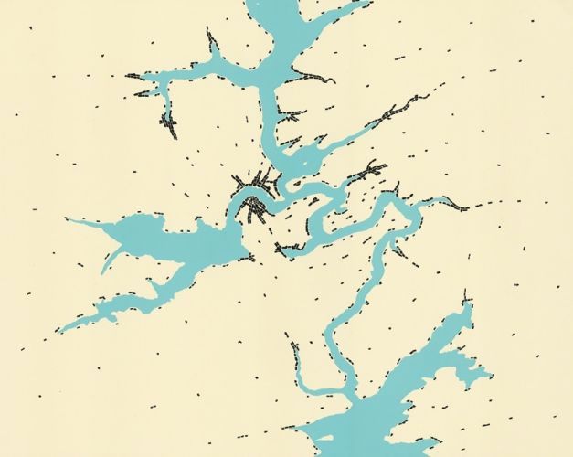
Luxembourg, "Slow"
2007 (Black ink on print) #07002This approach will take about 10,000 years. Over that time, the city of today would evolve into an almost completely different development.
-
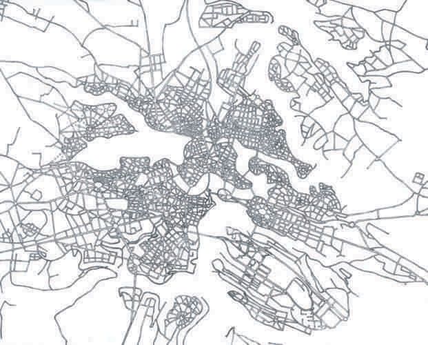
Luxembourg, "Fast"
2007 (Black ink on vellum) #07001The fast way to bring change is to build a dam downstream and bring the water level to 274 metres. This new landscape allows me to create a city in the Grand Manner of the French, where leisure, beauty and rationlity can reign...if you like things like that.
-
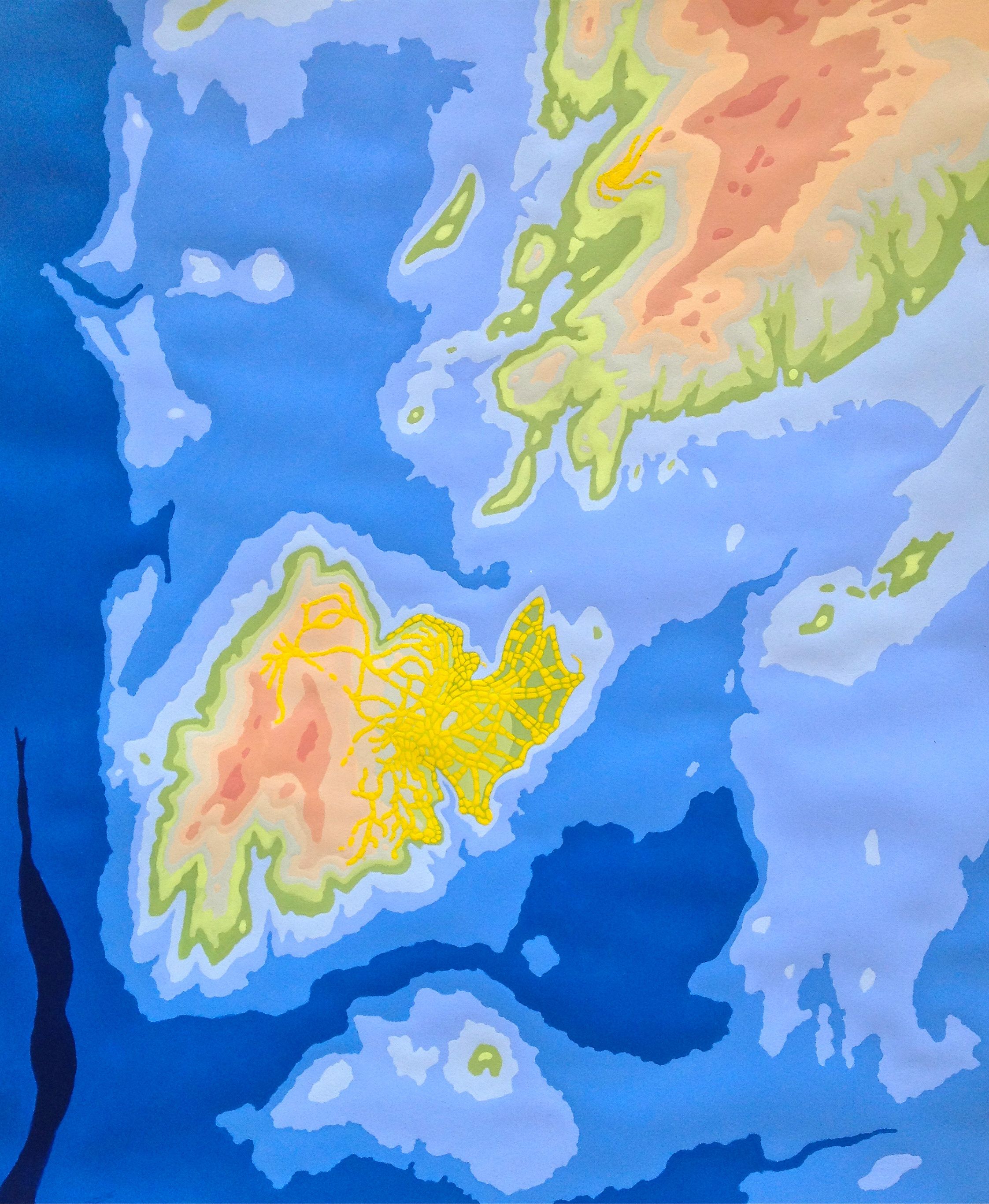
Isle St Restitut
Isle de St. Restitut 2012 (acrylic paint, multicolor) exhibited: Centre d’art Contemporain de St. Restitut